In the early hours of August 8, 2010, a huge mudslide struck the county town of Zhouqu in Gansu province, northwest China. On August 13, 1,156 people had been confirmed dead, 588 missing, and 20,000 affected by the disaster. [Editor’s note: This article was first published in Century Weekly on August 16, 2010].
Mudslides are natural disasters, but as China’s Ministry of Land and Resources has pointed out, such geological disasters can be caused by changes in natural conditions and by other factors, such as ill-advised human development.
In the early hours of August 8, 2010, with a noise like an approaching freight train, the Sanyan Valley suddenly saw 1.5 million cubic metres of mud and rock fall on a sleeping town.
Zhang Bin, chair of the county political consultative committee and a resident of Zhouqu’s Beijie Village lost his wife and child, along with his two-storey house built near a flood-control ditch. Thinking back, he said it seemed like “a conspiracy plotted by nature.”
The county seat of Zhouqu is only about three square kilometres in size, described as “a river between two mountains.” The river is the Bailong River, which runs through the tight space between Beishan (“North Mountain”) and Nanshan (“South Mountain”). The valleys of Sanyan and Luojia, from which the mudslides originated, are on Beishan. A downpour caused both valleys to flood, the floodwaters picked up rocks and earth, and the resulting mudslide rushed towards the Bailong River.
It was a disaster in two parts. First, the mudslide smashed across the town, leaving death and destruction in its wake. Then it reached the river and dammed it – and the river rose up to submerge large areas of the town.
Dawn found Zhang, a graduate in hydrology, sobbing as he stood in the ruins of his destroyed home. He struggled to convince himself he had suffered a disaster that could happen only once in several hundred years.
Parts of Zhouqu were built on the alluvial delta of the Sanyan Valley, and the people relied on it to survive. Without the Sanyan Valley, there would be no Zhouqu. But in retrospect it’s clear that the town was inviting disaster. A number of factors helped to cause and exacerbate the tragedy. An unusual downpour fell on dry and weak slopes that decades ago had been stripped of all vegetation. These were the conditions needed for a flood to become a huge mudslide. The town’s expansion over the years had encroached onto the riverbed, making the disaster yet worse.
The potential for a mudslide here had not been taken seriously. Land and water authorities – responsible for monitoring, warning systems and flood control – did not treat it as a serious threat. Every level of Gansu’s government and the local population ignored the risk. Sanyan Valley was not managed in accordance with the hazards that existed.
The disaster
On visiting Zhouqu, you can see at a glance what happened.
The county party committee and government buildings are built higher up and were fortunate enough to escape the disaster. The flood prevention and rescue command and the news centre are in these office buildings. Standing on their ninth-floor balcony and looking to the east, you can see a narrow zone of destruction – mud, huge rocks and shattered buildings – at the base of the mountain, widening towards the river to the south, like an open wound.
Locals recall that August 7 had been a hot, humid day. It started to rain about 11pm, with frequent thunder, but the rain itself was not heavy. For residents this was nothing unusual. Although the locals usually go to bed early, at midnight many were still awake enjoying the cool air.
But as the townspeople enjoyed the gentle rain, the mountains to the east and north were being hit by the largest downpour in a century. An unprecedented 96 millimetres of rain fell in a matter of an hour. The floodwaters rose and swept boulders and earth into huge mudslides through the Sanyan and Luojia valleys.
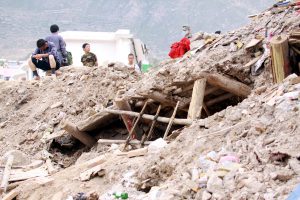
Like a marauding beast, the mudslide roared down the mountainside towards the town, killing locals and destroying buildings in over a dozen villages. The mudslide emanating from Luojia Valley destroyed most of the villages of Luojiayu, Chunchang and Wachang; while the mudslide from the Sanyan Valley left most of Yueyuan and Sanyan and part of Beijie flattened, leaving an expanse of mud 300 metres wide and five kilometres long. Hundreds of locals were buried and 20 buildings destroyed.
A lake formed behind the blockage when the mudslide reached the river, submerging the roads on either side of it. Even today many buildings on either side of the river stand in the water, some of them collapsed.
The densely populated areas that the mudslide passed through to the north of the river are low-lying, with some single-storey houses built even lower than the riverside road. These areas included the compound of the Bailong River Forestery Bureau’s 923 Forest Team. Sixty workers and their families lived there in three residential buildings. According to the deputy head of the local quality bureau, more than 80% of them died, including the director and his deputy. Looking in that direction, one could only see an expanse of mud and dirty water. The buildings may as well have never existed.
On the afternoon of the disaster, the minister for land and resources, Xu Shaoshi, said at an emergency disaster relief meeting that five factors had caused the huge mudslide, the most important of them being the particular geology and landform of the location. Around the valley mouth the land is precipitous, often sloping at over 50 degrees. The mountainside is a mix of mud and rocks, and the earth’s crust has clearly moved violently, with layers of rock twisted and loose.
Ma Dongtao and Qi Long, researchers at the Chinese Academy of Sciences and the Ministry of Water Resources’ Chengdu Institute of Mountain Hazards and Environment, carried out a survey of Sanyan Valley at the request of the Zhouqu government. In their paper, they said that the valley is a tributary of the Bailong River, with a catchment area of 26 square kilometres, and it is a western extension of the Xiqinlin mountains. It is influenced by the orogenic movement of mountain ranges including the Himalayas, with high mountains, deep valleys and extremely loose rock formations. Its highest point is at 3,828 meters, its lowest 1,340 meters – a difference of 2,488 meters. Its valleys are mostly V-shaped, or deep and narrow U-shapes.
Xu Shaoshi said that Zhouqu’s high mountains, deep rivers and severe erosion made it easy for mountainsides to become loose and cause geological disasters. According to Xu, other factors contributing to the landslide included instability caused by the Wenchuan earthquake in May 2008, which also hit Zhouqu; the drought in southwest China during the first half of 2010; and the sustained rain and sudden downpour.
In an interview with Century Weekly after the disaster, Ma Dongtao said that natural factors were mostly to blame and many other experts agreed. The downpour was a once-in-a-century event. The mudslide was inevitable and could not have been prevented.
Disappearing forests
Natural disasters cannot be stopped, but many experts and local officials agree that human actions exacerbated the tragedy.
Looking north from many points in the town, the sides of Beishan had been stripped almost bare of vegetation. Only on looking carefully could you see a few small trees. In the Sanyan Valley, there is very little grass on the sides of the gully, there are just some locust trees planted here and there.
But several kilometres into the gully, on a peak called Cuifeng, ancient trees stood tall and green. A worker with the Zhouqu forestry bureau said that the trees used to spread over 20 square kilometres around the gully, even around Zhouqu itself.
Prior to 1949, Zhouqu was known for its springs and its similarity to southern China. County official Zou Weidong explained: “Zhouqu was watered by the Bailong River, the largest tributary to the Qinling River, with tall green mountain pines on both banks. Groundwater was plentiful, with many springs – Sanyan Valley was named for three springs nearby.”
Fan Changjiang, a pioneer of Chinese journalism, visited Zhouqu – then known as Xigu – and the banks of the Bailong River, in August 1935. In his book, The North-West Corner of China, Fan wrote: “The banks of the river are fertile and beautiful, with both crops and fruit trees growing. There are large harvests of peaches, persimmons, pears and peppers.”
The transformation from forest to bare mountainside started in the 1950s and ‘60s, as China embarked on mass tree-felling as part of a reckless program of construction. According to the county gazette, during the Great Leap Forward in 1958, the local forestry authorities started widespread felling which continued until 1978.
One local forestry official said that between the 1950s and 1990s, both state and provincial forestry authorities took large quantities of timber from Zhouqu to use in construction. As the timber was moved by river, the banks of the Bailong were stripped bare. Now you can only find forests deep in the mountains.
In 1998, the Chinese government realised the damage that had been done to the environment and sealed off many mountain areas for forest restoration. But there is still no green on the banks of the Bailong River, even 12 years later.
One member of the county forestry bureau said that during those years the local government had sent workers from various departments into the mountains to plant trees, but there were no efforts to look after them and the trees’ survival rates were very low. The water authorities later contracted out the barren mountains to farmers, who received government subsidies for successful tree-planting, a method that proved more successful.
But it was too little, too late. He added that the original forest had been felled decades earlier and that earth had long since been washed away. This, and the reliance on rainfall for water, meant that survival rates were still low and trees grew slowly, taking years to reach even knee-height. “We are planting saplings but not seeing any trees,” he said.
One symptom of the destruction of Zhouqu’s ecology through deforestation is the sharp drop in annual average precipitation. Many of Zhouqu’s springs have stopped flowing. The Sanyan springs have mostly dried up. Ma Dongtao and Qi Long’s 1996 survey found landslides within these gullies had caused four huge dams of fallen rocks between 80 and 283 metres in height. These rocks would be swept up by any mudslide.
Accumulated environmental degradation increased the chances and scale of disaster. Interviewed after the mudslide, Ma Dongtao blamed movements of the earth’s crust and the 1879 Wenxian earthquake for the severe landslides within the Sanyan Valley gully – but environmental degradation in the area was also a factor.
Some believe that human activity, such as hydropower development on the Bailong River, also increased the risks of mudslides. Ma said that while humans do damage their environments by felling trees, clearing forests for farmland, quarrying, constructing hydroelectric dams, building roads and so on, these are still secondary factors compared to natural changes.
Unchecked expansion
The huge mudslide would not have been a disaster had it not affected humans in the area. Over the last two decades, spurred by a rising population and a lack of planning, the town of Zhouqu expanded into Sanyan Valley, with building even on the riverbed itself.
Originally there was a riverbed hundreds of metres wide running from the gully to the river. The county gazette records people living mostly on the banks of the river, and by the sides of the tributary flowing out from Sanyan Valley.
There seems to have been one minor mudslide in the 1960s or ‘70s. The local government then built a flood control ditch in the river bed. Residents recall it being nine or 10 metres wide and three or four metres deep. Once that was constructed, new buildings quickly appeared alongside the valley. About 20 years ago the government rebuilt the ditch to be six or seven metres wide and four or five metres deep. This sparked off another round of building on the river bed.
The population of Zhouqu has doubled from 20,000 to 40,000 people over the last two decades – a huge challenge for a county town less than three square kilometres in size.
Ma Dongtao said: “Places prone to mudslides such as Zhouqu must take that danger into account and avoid construction in risk-prone areas.” But urbanisation saw communal land bought and sold under the table, with new arrivals buying land contracted out to residents. The original residents continued to move into Sanyan Valley and Luojia Valley. The most northerly part of the town, Sanyan and Yueyuan villages are on the two sides of Sanyan Valley, and in recent years have built right up to the edge of the flood control ditch. Yueyuan has even reached the bottom of the riverbed, with residents filling in and building on that ditch, which in some places became less than two metres wide.
This was partly due to the needs of a small town facing rapid urbanisation, but more important was a lack of scientific urban planning. The county is only in the first stages of urbanisation. Apart from government offices and residential buildings, most land is held by Chengguan township. Yang Sanbao, deputy head of the county construction bureau, said that only an overall plan for the town had been fixed. There was no detailed planning. Land transfers in recent years were grey-market sales of public land, which the planning and land authorities had not addressed.
Our investigations found that apart from the residential buildings allocated to government workers from the Public Security Bureau, the courts and so on, there were virtually no commercially-traded properties in Zhouqu. Nor had the increase in population lead to more restrained use of land; people had constructed two- and three-storey buildings everywhere. Moreover, even government heads and political figures were living in buildings constructed on public land. Li Aihui, deputy of the construction bureau with responsibility for planning, had built his home in Yueyuan Village. He and seven family members were killed.
Missed warnings
Many outsiders have asked why there were no warnings as the flood and mudslide headed towards Zhouqu. The county has long had an early-warning system for landslides and mudslides. It was established in the 1990s by the Yangtze River Upper Reaches Water and Earth Retention Commission Office at key points on the Upper Yangtze, as part of the International Decade for Natural Disaster Reduction.
“This was China’s first such system, and to date it is still the largest,” said Zhang Xiaolin, senior engineer with the Yangtze River Commission’s Water and Earth Retention Bureau and head of its supervision office. As well as the second-level station at Zhouqu, there was a larger first-level station in the Longnan area.
But he said that the station’s failure was because the downpour was very localised. Built at the end of the last century, the system could not account for risks that developed over a large area. The rain on August 7 was unevenly distributed over Zhouqu county. “The rain that fell on the station wasn’t enough to trigger a warning,” said Zhang.
There are another two monitoring points near the site of the disaster, but these are designed to monitor landslides. They were unable to warn of a mudslide. “On a national level, our systems struggle to warn of mudslides caused by sudden downpours. Even if we cooperate with local meteorological bureaus, there’s limited monitoring of the weather,” Zhang said.
Zhang explained that the warning system, funded by the ministry of water resources, is overwhelmed due to a lack of funding, which has limited the number of stations and the quality of equipment. After restructuring, the system was left with only one central station, three primary stations, eight secondary stations, 56 monitoring and warning points, and 18 counties where the local population were involved in monitoring and prevention.
“There are less monitoring points than in the Three Gorges Reservoir,” said a disappointed Zhang. “A lot of equipment only lasts for a decade or more, it is aging and some of it should be discarded. There is no way it can keep up with the situation. There are landslides or mudslides almost every month, especially in places like Longnan, where it can happen in any valley.”
He explained that the funding for the system comes from water resource infrastructure funds, annually 3 million to 5 million yuan (US$460,000 to $765,000), which can only be used to build new stations. There is no funding to actually run the system.
The coverage of the geological disasters warning system operated by the land and resources authorities is also limited. Xu Xiaoshi, minister for land and resources, said that two-thirds of areas at risk are not covered. Even in those areas that are covered, information is only collected at a few points.
Since the risks at Sanyan Valley were not taken seriously, there was little education for residents on what to do in case of disasters. When disaster did strike, the government was quick to sound civil-defence alarms, but nobody knew what they meant. Several minutes of precious time were lost and few people escaped.
Relocate or rebuild?
After the catastrophe, the wounded town faced a painful choice. To rebuild on the original site of the town, or relocate entirely? At a press conference on the afternoon of August 11, the head of civil affairs for Gansu, Tian Baozhong, was the first to raise this issue. He said that no decision had been made on the matter, but that it was unlikely the rebuilding would take place at the same location. He asked: “What if it happened again?” One possibility was to erect a memorial on the site of the disaster and rebuild the town elsewhere.
But when asked the same question later, Tian refused to comment.
It wasn’t the first time this had been suggested. After the Wenchuan earthquake in 2008, Zhouqu received attention from domestic and international media. Visiting Zhouqu a month after the quake, the director of Lanzhou University’s Urban Planning Institute, Chen Huailu, found the town at high risk of geological disaster. He suggested to an official from Zhouqu People’s Representative Committee that the town be relocated.
Interviewed by Century Weekly, Chen said that the official had taken his suggestion to the county party committee and the government. But ultimately his proposal was not adopted. The government offered three reasons why: lack of funding; the difficulty of obtaining approval from the Ministry of Civil Affairs; and the lack of anywhere better to relocate.
Many Zhouqu government officials said that either choice would be difficult. Using the original site would require removing two million cubic metres of mud – around 130,000 truckloads. Moreover, it would be impossible to guarantee another mudslide would not occur.
Relocation would mean abandoning decades of investment in infrastructure and forcing some people to leave the place that had been home to their families for generations. Zhouqu came to be the county town by a process of elimination: look at the other towns along the Bailong River and you will not find any as large as Zhouqu, and they are also at risk of mudslides.
Zhang Bin, of the county political consultative committee, said that Zhouqu’s 2,000-year history proves it is a suitable place for people to live. The problem was the layout of the town and its overpopulation. There is a compromise: cut back the population and shrink the town back into the centre. The excess population could move to nearby towns, such as Fengdie, 15 kilometres away.
But perhaps the most important question is whether the government at all levels can learn the lessons of Zhouqu, with a complete survey of geological risks in areas prone to landslides and mudslides, and the relocation of people or management of risks as appropriate. It was chance that led to the downpour near Zhouqu. All of southern Gansu – and many parts of China – suffer the same poor geological and environmental conditions. Where might the next Zhouqu be?
Gong Jing, Wang Heyan and Zhang Ruidan are reporters for Century Weekly.
This article was first published in Century Weekly, August 16, 2010.